Using Terrain Height Map Generator
 launok
Posts: 793
I have tried this out after playing with it some time ago but not sure if I am using it correctly.
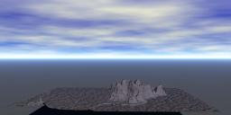
Trying it out the whole mountain was like squashed in, way out of proportion. I have then tried using a Y button to flatten it down as to get the proportions more realistic which worked.
But since this is one solid model it can't be ungrouped. I can not change colours, i.e. sea part is exactly same as rest. Are there a certain way to export the model to be able to use colours on different parts?
EDIT: forgot that I have a similar question earlier on. Will go and see the suggestions!


cp1.jpg
1194 x 563 - 241K


cp2.jpg
1194 x 563 - 288K


cp3.JPG
1366 x 768 - 149K
Post edited by launok on


Comments
launok, explain to me what is your ultimate goal? Do you want to create a global 3D map of the area? Do you want to create a beautiful global mountain landscape? Do you want to create a local mountain landscape with a river and vegetation? These completely different tasks require a different approach.
In the next branch, I answered the question of coloring the terrain and water, but you ignored it. To use the real colors of real terrain, you need to have a map resolution of 64k or higher. No computer can handle this task. And how will you customize materials of rocks, sand, water, etc.? So you need to have a few more maps: transparency, reflections, bump, specular, etc. Throw it all out of my head and read my recommendations in the next branch.
Send me a height map in PNG, TIFF or BMP format by mail and I'll show you how to do this. And yes, proportions must be respected. That is, you need to know what the actual height of the mountain and the length of the side of your terrain.
There are several way to achieve the effect.
Most people simply set the ground plane to a water material and then put the terrain slightly underground. Then you've got an island floating in an infinite ocean. The materials for the land and the water can be edited and changed independently.
You can also set up a more complex terrain material that has a water effect in the lowest levels. The problem with this is that unless your caemra is a narrow view, it's difficlt to make a material on the ground/water plane that will match.
You can also use the filter sliders at the right side of the greyscale top view window of the terrain editor to filter out anything above or below a certain level. The icon that opens these controls is at the top right of the greyscale top view window and looks like a document icon (See arrow 'A' below). Then slide the top of the bracket down (See arrow B) or the bottom of the bracket up (See arrow C). You will see yellow and/or red appear next the bracket and corresponding yellow and red patches on the greyscale picture to the left and anything above or below where you set it will be invisible. So you could effectively duplicate your terrain and using those controls, split your terrain to apply different materials to each part.
Slepalex - Just a local landscape is what I am after to which I can add my own buildings, trees, vegetation, etc. But in the case of Table Mountain to have the actual sea in front will be nice too (in colour). I am living in South Africa and want to create more such scenes from my area. I even want to go further in creating scenes from other areas, i.e. westerns, where I can go to places such as Colorado, etc. Using Bryce's own terrains are not always giving me the effects I want.
Dave Savage - thank you for your advice too, appreciated.
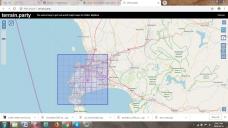
The thing is that this shit called "http://terrain.party/"; when exporting the ocean level is gray instead of black. The minimum area is a square with a side of 8 km. And to create a decent landscape, you need to create at least 3 areas from this map: 200 * 200 m with a resolution of 2k, then 400 * 400 m with a resolution of 1k, then 800 * 800 m with a resolution of 0.5k. These are the areas that must be followed one after the other.
Here is the heights map of this shit. Sea and coast. I adjusted the brightness and contrast of the height map several times, then processed it in GeoControl2 and then loaded it into Bryce. And what happened? Look at the ocean level! It occupies three-quarters of the height of the whole terrain.
My opinion: throw it all in the trash and do not remember.
Slepalex - thanks again. I have send you a PM.
Buildings, trees for a landscape can be laid on the terrain of 200x200 meters. For this you do not need a height map with a side of 18 kilometers. For this you don’t need a height map at all. The height map you need for the terrain of the second and third plan with all kinds of table mountains and hills.
And here's another thing: stop looking for the "make beautiful" button. Learn to draw a height map in TE, then correct it in Photoshop, and then you can edit it for example in GeoControl2.
I have done a search now on GeoControl2 = it seems now called World Creator = which needs Unity. Unfortunately I can't afford buying any of these software. I am a pensioner and can currently only opt for freebies.
launok, check your email.
Slepalex, thanks!
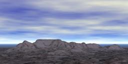
Here I have tried something else by added a separate terrain with water mat. Not perfect but one can see it's Table Mountain.
I only used terrain party once or twice but made adjustments in Photoshop.
Launok - it looks nice, but I think you need to attach it to land, I don't think it's an island, not from the pictures I saw.